


Earlier this month, I was fortunate enough to be invited to the Project Launch of of GB1900; the first ever historical gazetteer of the entirety of Great Britain, capturing the isles between the years 1888 to 1914. I was invited by Humphrey Southall, Professor of Historical Geography at the University of Portsmouth. Dr Southall, who led the Project end to end, had previously delivered several Wikipedia in the Classroom courses, as part of his Geography modules at the The University of Portsmouth. The GB1900 project is unique and groundbreaking – or ground forming perhaps – in several ways. Most significantly because the project’s data points were entirely transcribed, with their coordinates then verified, by volunteers. And not only does the project begin with volunteers, bringing together the data for us all to see (as demonstrated below), the project’s data is open to use under Creative Common’s open licensing – the particular licensing depending on what form you would like to use the data in.
“GB1900 is a crowd-sourcing project to transcribe all text strings from the second edition six inch to the mile County Series maps published 1888-1914. The project is a collaboration between the National Library of Scotland, the Great Britain Historical GIS team at the University of Portsmouth, the Royal Commission on the Ancient and Historical Monuments of Wales, the University of Wales Centre for Advanced Welsh and Celtic Studies, the National Library of Wales and the People’s Collection Wales.
The final goal [was] to create the largest historical place-name gazetteer for Great Britain specifically including co-ordinates.”(1)

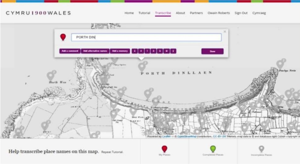
A screenshot of Cymru 1900’s user interface
So why create a gazetteer of Great Britain, when you are trying to understand the lay of the land at a frozen point in history? Why not simply rely on old maps? And perhaps it’s worth detailing what entails a gazetteer to the non-geographers among us… A gazetteer is a ‘geographical dictionary’, to be used alongside a map or even an atlas, which gives more detailed description of the physical or geographic features of an area, at ‘land-level’. The presentation of the project began detailing the versatility of a gazetteer as a medium, stating that gazetteers “… are better than maps!” Historically, we have many more gazetteers to rely upon than maps, which are comparatively, a more recent phenomena – with maps only being commonplace from the 18th Century. Secondly, gazetteers are functional for walkers and navigating new areas – with descriptions of landmarks, as and when you come by them, (on a weekend stroll perhaps).
What were the team looking to achieve by transcribing a gazetteer or Great Britain, frozen in 1900? “We have three main aims. Firstly, to contribute to the overall development of “citizen science” by showing how working on particular local areas that matter to them affects the motivation of volunteers.” Following on from this, the team hoped that the project would encourage similar online crowdsourcing projects. Lastly, the project team wished to demonstrate how their work benefits the general public, “…we need to show not just that many people use our websites, but to report on what our sites help people to do.” (2)
The project’s process & outcomes
A need was identified for ‘a new historical gazetteer’ of Britain, as pre-existing historical gazetteers had partial data on either postcodes, features or parishes – but no completely descriptive gazetteer available as a whole. Discussions for such a project initially began in March of 2011, at first as ‘Cymru 1900- Historic Place names of Wales’, . After forming partnerships supporting the idea, the People’s Collection of Wales, the Centre for Advanced Welsh & Celtic Studies, National Library of Wales and the Royal Commission on the Ancient and Historical Monuments of Wales, decided to create a uniquely crowdsourced Welsh historical place name gazetteer. The collaboration then further partnered with the citizen science platform, Zooniverse, to host the development of the project’s bespokely required interface system. The website ‘Cymru1900wales’ was launched by October 2013, with transcription of the historic Ordnance Survey maps active until their completion in September 2016. The place names transcribed and verified by the volunteers in that time for the Cymru1900 gazetteer, were then also able to contribute to The List of Historic Place Names of Wales index, quickly being able to demonstrate the versatility of open- citizen-sourced data.
Soon after the successful completion of Cymru 1900, the project was then decidedly extended to attempt to transcribe the rest of Great Britain towards the end of 2015. In order for this to be achievable, it was recognised that several more volunteers were needed to be recruited, who would be fundamental in the execution of the project. The volunteers ideally would need to have an idea about transcription, and be interested in the History of Great Britain; the team turned to advertising part way through the project, through the ‘Who Do You Think You Are’ magazine’s ‘Transcription Tuesday’ initiative. This proved successful in adding some new faces to the team of dedicated volunteers who were enamoured by the project’s aims.
The team and volunteers proceeded to run with the GB1900 aims without funding, having officially launched their volunteer engagement in September 2016 and using high quality, historic map scans from the National Library of Scotland. A separate supporter site was then created for the volunteer’s to interface, building upon the successful format used for the Cmyru1900. The site designed so that volunteers could track the ‘contribution leaderboard’, and take a look at the maps as their data points grew in progress. At the project launch, by happenstance, I sat next to one of the many dedicated volunteers, who shared their delight not only at participating in the place-name subscription, but also the opportunity to share personal ‘place-memories’ of the areas they were working on, through the volunteer interface. By January 7th 2018, the whole of Great Britain at ‘1900’ had been completely transcribed. This of course was with great thanks to the 1000+ volunteers, several of which were presented to have given up to 20 hours a week to the project. Awards were given to the volunteers who had given the most hours, in the appropriate form of the printed ordnance survey maps, from the National Library of Scotland, featuring the regions that the volunteers has contributed the most to.

“In total, the volunteers located 2,666,341 strings on the maps, and contributed 5,500,339 transcriptions. It is hard to see how this could have been matched by an academic research team.” (3)
Following the presentation of the project, Dr. Southall and Paula Aucott, research associate of the project, used the opportunity to encourage the use of the open data – following the example of the proven versatility of the Cymru1900 project before hand. On the project’s website – it is made clear to whoever might interested, what forms of data are available e.g. the project’s ‘raw data’ or as ‘cleaned versions’ of the data – matched with the coordinates and modern district names of the transcribed place names – and what license they’re available under – e.g. CC by 0 & CC by SA, respectively. There were following presentations, giving insight to initial uses of the data set; by representatives from the University of Wales Centre for Advanced and Celtic Studies, demonstrating the historic linguistic research now attainable through the transcribed place names, and from The Ramblers, demonstrating how the data can be used for their Finding Historic Footpaths project.
Attending the project’s presentation was a clear demonstration of the possibilities of citizen science, with even just a small and dedicated team coordinating it’s growth and volunteer engagement behind the scenes. What was most poignant to me as an attendee of GB1900 launch, was the personal experience that was resonant with many of the volunteers who transcribed the coordinates of the gazetteer, with many focusing on areas where they had once lived or spent holidays. The project and it’s now open outputs reside within a wonderful overlap, whereby this new formation of data is not only useful, but has brought to life personal histories of places across britain, that were always there, simply waiting to be noted, and brought together.
To see the data sets, you can visit the Vision of Britain website.
- https://s3.eu-west-2.amazonaws.com/sheetlines-articles/Issue111page46.pdf
- https://support.gb1900.org/portal/kb/articles/gb1900-volunteer-study-participant-information
- https://s3.eu-west-2.amazonaws.com/sheetlines-articles/Issue111page46.pdf